Verified
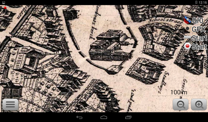
Mechelen 1649
19:23 Feb 28 2015 Mechelen, Belgium
Description
Mechelen / Malines / MechlinMechelen is one of Flanders' prominent cities of historical art, with Antwerp, Bruges, Brussels, Ghent, and Leuven. It was notably a centre for artistic production during the Northern Renaissance, when painters, printmakers, illuminators and composers of polyphony were attracted by patrons such as Margaret of York, Margaret of Austria and Hieronymus van Busleyden.
The highly lucrative cloth trade gained Mechelen wealth and power during the Late Middle Ages and it even became the capital of the Low Countries (very roughly the Netherlands, Belgium and Luxembourg) in the first half of the 16th century under Archduchess Margaret of Austria.
During the 16th century the city's political influence decreased dramatically, due to many governmental institutions being moved to Brussels. Mechelen compensated for this by increasing prominence in the religious arena: in 1559 it was proclaimed the Archdiocese of Mechelen, seat of religious authority over the territory that would eventually became Belgium.
The map (monochrome) is from the "Altas van Loon" version of Joan Blaeu's Stedeboek.
Additional Data
| year: | 1649 |
| accuracy (m): | 15 |
| map size (Mb): | 525 |
| artist: | unknown |
| publisher: | Joan Blaeu |
| wikipedia: | http://en.wikipedia.org/wiki/Mechelen |
| image source: | Wikimedia, CC-BY-SA 2.0 |
| map download link 1: | www.geotiek.nl/media/B-Mechelen-1649-jBlaeu.zip |
| map download link 2: |
| Credibility: |  |
 |
0 |
Leave a Comment