
Verified
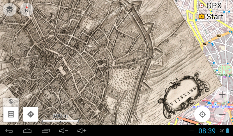
Brussels 1649
18:24 Jun 29 2015 Brussels, Belgium
Description
Really nice map of Brussels / Bruxelles by Joan Blaeu, uncolored and with nice clear lines.Brussels has grown from a 10th-century fortress town founded by a descendant of Charlemagne to a sizeable city. Because of its location on the shores of the Senne on an important trade route between Bruges and Ghent, and Cologne, Brussels grew quite quickly as a commercial centre. As it grew to a population of around 30,000, the Counts of Leuven became Dukes of Brabant at about this time (1183/1184). In the 13th century, the city got its first walls. A second set of walls was erected between 1356 and 1383, today, traces of it can still be seen, mostly because the "small ring", a series of roadways in downtown Brussels bounding the historic city centre, follows its former course. In the 15th century, by the wedding of heiress Margaret III of Flanders with Philip the Bold, Duke of Burgundy, a new Duke of Brabant emerged from the House of Valois. Brabant had lost its independence, but Brussels became the Princely Capital of the prosperous Low Countries, and flourished. In 1516 Charles V, who had been heir of the Low Countries since 1506, was declared King of Spain in St. Michael and St. Gudula Cathedral in Brussels. in 1519, Charles became the new ruler of the Habsburg Empire and was subsequently elected the Holy Roman Emperor.
In 1695, King Louis XIV of France sent troops to bombard Brussels with artillery. Together with the resulting fire, it was the most destructive event in the entire history of Brussels. The Grand Place was destroyed, along with 4000 buildings, a third of those in the city.
Since the end of the Second World War, Brussels has been a major centre for international politics. Hosting principal EU institutions, the headquarters of the North Atlantic Treaty Organization (NATO), the city has become the polyglot home of numerous international organisations, politicians, diplomats and civil servants. Historically a Dutch-speaking city, it has seen a major shift to French since Belgian independence in 1830. Today, although the majority language is French, the city is becoming multilingual with increasing numbers of migrants, expatriates and minority groups.
Additional Data
| year: | 1649 |
| accuracy (m): | 35 |
| map size (Mb): | 250 |
| artist: | Joan Blaeu |
| publisher: | Joan Blaeu |
| wikipedia: | https://en.wikipedia.org/wiki/Brussels |
| image source: | Wikimedia, Universiteit van Amsterdam Netherlands |
| map download link 1: | https://www.geotiek.nl/media/b-brussel-1649-jBlaeu.zip |
| map download link 2: |
| Credibility: |  |
 |
0 |
Leave a Comment